Friday, September 30, 2011

Kunashir, Russia, August 2011

I had a very unique experience traveling to Far East Russia, Sakhalin province, Kunashir island, in August.  Here is the executive summary of my official report along with pictures and captions.  If you would like to receive the full report, please contact me.

Executive Summary.   Territorial disputes are real issues in East Asia, and the ones concerning Japan and its neighbors often make the news in the countries involved.  Japan currently has disputes with China, South Korea and Russia, the issue with Russia involves the largest amount of land and people.  In Japan the dispute is called the Northern Territories Problem.  There are four larger islands in the center of the dispute and many small islands also involved.  The island of Kunashir is the closest to Japan and the most populated and developed.

                Japanese middle and high school textbooks still read that these islands belong to Japan but are being administered by Russia.  If occupation means ownership, however, then these are most certainly Russian islands.  Kunashir island contains two military bases with a homogenous Russian population of about 5,000 citizens engaged in commercial fishing with tourism as a second, smaller industry.  The Federal Security Service/Bureau (FSB) is prominent on the island, and the island community operates like any Russian territory.  In 2010 the region, or state, of Sakhalin to which Kunashir belongs celebrated its 65th anniversary of its liberation from the Japanese.  Billboards and other items commemorating that milestone remain visible today.
                However, there exist interesting factors to consider that the future of Kunashir is not fixed in place.  The population of Kunashir is in decline, now 5,000 from a height of 15,000 about ten years ago.  The fishing industry produces only for Western Russia export: seafood costs more to buy on the island than it does in Moscow.  The island’s extremely unique and beautiful geography attracts Russian tourists and some international vacationers but the industry languishes in a second-world state of management.  The citizens of Kunashir speak candidly of their impression that unless their government reinvests in the area, it is only a matter of time before the Japanese move in and quickly develop it.
                Within this framework there exists visible though low-key reciprocal engagement between Japan and Russia.  Cultural exchange takes the form of annual conferences and public effort on the main island of Sakhalin.  On Kunashir, there exists a Russian and Japanese Friendship House, built by the Japanese 12 years ago, which cultivates positive sentiments from the island’s populace.  More formally, Russia continues to allow visa-free, tightly guarded trips to groups of Japanese citizens who come onto Kunashir and visit the graves of their ancestors- perhaps the most prominent issue in the territory dispute from the Japanese perspective. 
                At this time, it appears that neither Japan nor Russia is in a position financially or politically to commit to truly resolving this territory dispute.  There still remain deep emotions on both sides toward the issue, at least at the senior leadership level.  A question remains as to if those strong sentiments will be handed down to future generations of Russians and Japanese so as to make the issue remain difficult, or whether the next generations will decide to let the emotions of the old war fade into history and instead look at the area with a more pragmatic mind toward the strengthening of two distinct cultures that merge in unique ways on these islands. 

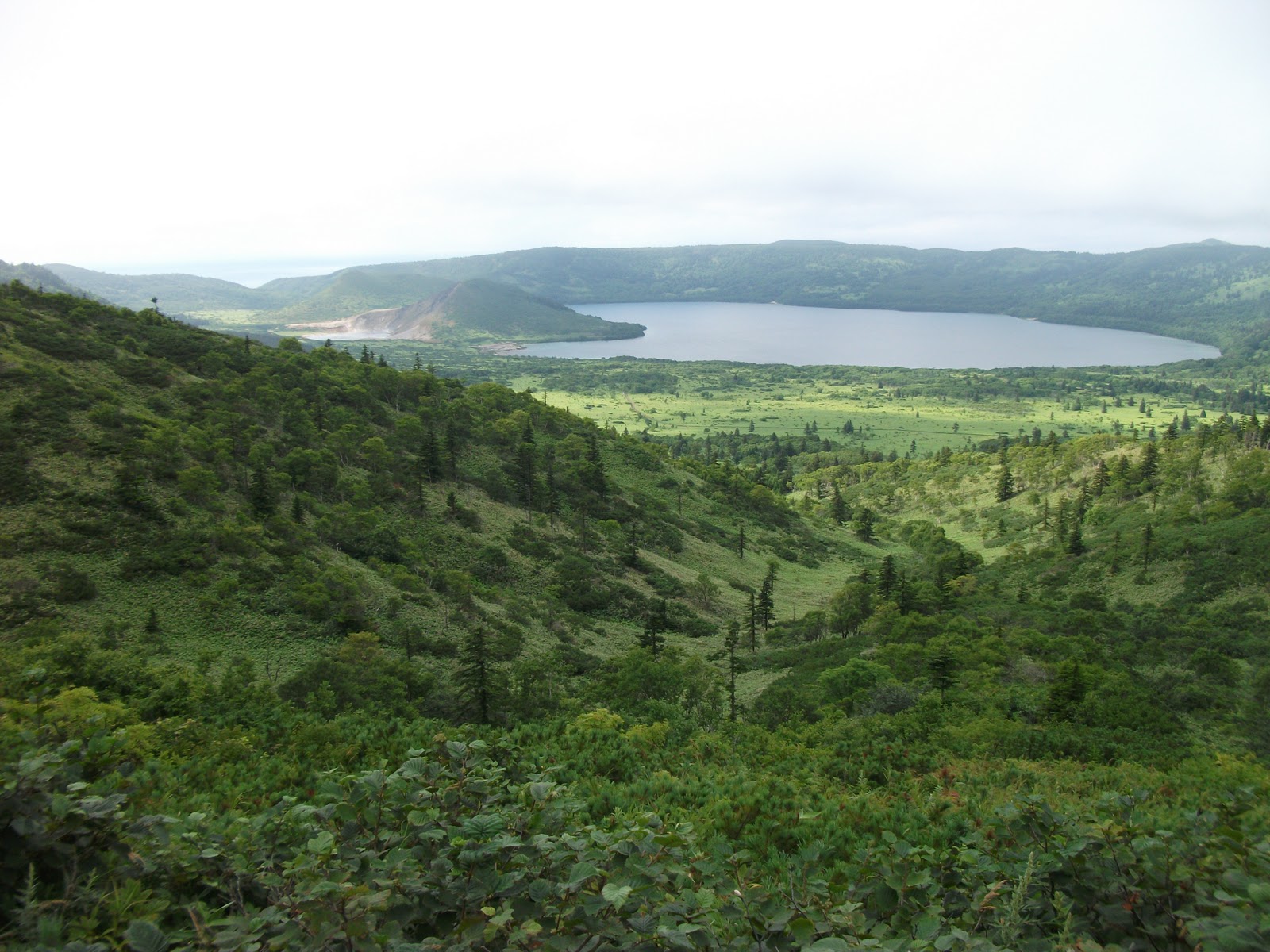
-A volcanic lake valley.  The small sulfur lake to the left was channeled into the fresh water lake by the Japanese.

-Mt Mendeleev, the high peak on Kunashir, named after the Russian father of the periodic table of elements due to so many kinds of minerals found around the volcano.

-A picture of a group of Japanese citizens preparing to depart the island via boat after visiting family gravesites; the entire visit to the island lasted only 12 hours and the group was tightly escorted by Russian FSG personnel.

-An example of a Japanese cemetery, the marker in the center records a surprisingly recent date of 2004, though other markers date into the Showa era prior to WWII.

-An example of a Russian cemetery, connected to the Japanese site in the other picture.

-An example of the hexagonal rock formations found on one of the coasts. 
-Another example of the unique rock coastal rock formations.


-Inside a taxi, an interesting decoration hangs from the mirror: a Russian Orthodox icon of Jesus Christ but decorated with Chinese designs.      

-A full statue of Lenin in the downtown train station park of Yuzhno-Sakhalinsk.    
–A recently renovated Russian Orthodox church in Yuzhno-Sakhalinsk. 

–A memorial park area commemorating the liberation of Sakhalin from the Japanese in 1945.     

-A lone rock formation on a beach, called both The Candle or the Devil’s Finger (a discarded bottle of Japanese Asahi beer was found nearby and set upright for effect). 
-A bust of Lenin in the town square of Yuzhno-Kurilsk.       

-The Russian and Japanese Friendship House, located in the center of Yuzhno-Kurilsk and built by the Japanese 12 years ago to promote warm relations.

-Sunset view from the Kunashir hotel.  That is a peninsula spur of Hokkaido seen on the far horizon.  

-A business center in Yuzhno-Sakhalinsk with a lone banner on the front entrance announcing the 6th Annual Russia and Japan Cultural Exchange Conference, occurring for four days.

.     –The provincial museum in Yuzhno-Sakhalinsk, displaying distinctively Northeast Asian design and architecture.

-In Yuzhno-Sakhalinsk’s provincial museum, an outside display of a Japanese artillery cannon with a Meiji era date engraved on the barrel.

Monday, July 25, 2011

Seoul-Okinawa-Guam, July 2011

This post is taken from the Executive Summary and photos/captions of my report on this trip.  If you'd like the more detailed report, let me know, I'd be happy to send it to you!


The U.S. military presence in Korea, Okinawa, and Guam represents a majority of our strategic presence in Asia.  These areas are currently in a state of flux, though mostly at the political level at this point in time.  Korea is the most stable of the three at present but it is also the most strategically positioned, tactically forward, and therefore tense environment.  Okinawa and Guam are vital players in the national political negotiations of U.S. force realignment between America and Japan.  Weaving through all three of these areas is a complex convergence of histories and cultures that will no doubt shape the future in ways that may be difficult to predict and detect, but which nonetheless deserve future study and discussion at all levels of military and government.
                The common thread of this trip was, in my opinion, the role of the United States as big brother and how each area responds to that relationship.  South Korea clearly embraces its alliance with the U.S., and our commitment of forces there is key to the myriad of unification scenarios that exist.  However, South Korea is also very much in competition with its Asian neighbors economically and desires to preserve its cultural distinctiveness after so many shameful years of colonization, so its attitude toward the U.S. can also become adversarial very quickly and with little warning, though the issues do not pose a threat to a continued strong relationship.  The prefecture of Okinawa, in contrast, is in a state of perpetual political conflict which has players at very different levels of government- from the national governments of Japan and the U.S. to the prefectural and even municipal governments on Okinawa- voicing strong opinions about how Big Brother is living in their neighborhood.  The unincorporated territory of Guam is another player in the U.S. force realignment which is connected to Okinawa.  While the Guam government is naturally pro-American, its dependence on Japanese, Korean, and even Chinese tourism, coupled with a vocal cultural minority vying for more independence from the States and against anti-force enlargement creates an environment that requires Big Brother to tread lightly there, as well.  Indeed, transparency and constant reassurance is needed in all these areas to maintain the U.S. presence with continued success.

The Panmunjom facility at the Joint Security Area of the Demilitarized Zone.  The Republic of Korea soldiers standing in the foreground only assume these positions when visitors are present, which can be many times each day- otherwise, they sit inside the Freedom Center behind the cameraman, which is not allowed to be photographed due in part to the large amount of surveillance equipment mounted on the building pointed toward the North.  A North Korean solider can be seen at the top of the steps across the way, observing the visitors: there is also another soldier on duty, observing from within a room to the right of the soldier.

A sculpture at the Tunnel #3 site on the DMZ conveys a desire for unification of the North and South.  Tunnel #3 itself was not allowed to be photographed, and is one of four tunnels discovered so far for the express purpose of infiltration.

The Dorasan Train Station, which now has a rail line that connects North and South and travels to Pyongyang.  No trains run through this station- it is rather a product of the Sunshine Policy of the past South Korean government to improve relations with the North.  It remains as a tourist destination and a symbol of desired unification.

A large picture poster of Dokdo Island, called Takeshima in Japanese.  This is part of a temporary exhibit at the War Museum which claims to desire to educate the Korean people on the issues surrounding the territory dispute but is also unashamedly accusatory in its propaganda campaign against the Japanese position.

The “Statue of Brothers” outside of the War Memorial of Korea museum in Seoul.  Its purpose is to promote the concept of unification, but it is interesting to note how each of the figures is sculpted.  The South Korean is the fully equipped soldier, listed as the “older brother” on the plaque, who is physically larger than the North Korean younger brother refugee seeking protection.

The Chibichirigama historical cave site in Yomitan Village, Okinawa.  On April 2, 1945, toward the conclusion of the Battle of Okinawa, 84 Okinawans of the 139 men, women and children hiding in the cave committed fratricide and suicide, pressured by the Japanese soldiers to do so, for fear of being captured and tortured by the Americans: 47 of the slain were infants and children under 12 years old.  The site is still well maintained by the city but is virtually unknown to Americans and Japanese alike.  It is indicative of many other instances of suicide that occurred during the Battle of Okinawa.

Inside the cave, a sampling of bottles and earthenware used by the refugees is left as an exhibit without additional explanation: among the items are pieces of bone and teeth.

A picture of the ubiquitous Okinawan shi-shi, or shisa, dogs or lions, as they are called various names.  These sculptures are placed, almost exclusively in pairs as shown here, at the entrance to homes and civic buildings of importance.  Similar statues can be seen in mainland Japan and China, but not nearly as profusely and usually alone sitting on a rooftop.  This display type marks Okinawa as distinct and the Okinawan people have continued a concerted effort to make it so, which is, in my opinion, indicative of the continued effort for Okinawa to maintain its Ryukyu culture separate from the nation of Japan.

A vinyl sign is posted outside the main gate of Marine Corps Camp Courtney, home to the Headquarters of III Marine Expeditionary Force and 3d Marine Division.  It is printed in both English and Japanese, and says, “To AAFES:  Do Not Impose Excessive Workload on Employees by Establishment of Unreasonable Productivity (Norm)!”  I was not able to learn who wrote it but the kanji appears to be division from the Zukeran workers organization.  An almost constant presence of protests in written form is the normal environment surrounding the bases, run by an organized minority of citizens who do not represent the majority of Okinawan people or their interests.

Guam’s headquarters for the Soka Gakkai International- USA Chapter, off of main route 1.  Soka Gakkai is a Japanese Buddhist denomination that is powerful enough to support its own political party, the New Komeito Party, which has a significant presence in Japanese national politics.  The organization also boasts a strong international following.

A recreation area off of route 1 with a sign stating “Alcohol Free Zone:” the place was littered with cigarette butts and other trash, including beer cans.  There are other signs on the island but they are far outnumbered by the number of bars, clubs, convenient stores, radio and TV stations that strongly advertise alcohol.  

A historic monument site of Japanese artillery fortifications on Guam.  The Japanese flag is flown along with the U.S. and the Guam flags.  In fact, Japanese flags are flown in other areas around the island, as well, and it is my opinion that it is done deliberately in order to make peaceful overtures to the Japanese resident population and to the Japanese tourist population which accounts for about 75% of Guam’s tourism.

The Sergeant Yokoi Cave dedication site at the Tolofolo Falls museum center.  Japanese soldier Sgt Yokoi survived in hiding near the waterfalls for 27 years, and was brought out of the jungle in 1972.  He is regarded as a hero in every publication on the island, but I was not able to discover any information as to why he chose to stay there for 27 years!  


The last two pictures were taken in the Pacific War Memorial attraction site, which was created by former Marine John Gerber, who is depicted in the second photo.  He was a resident Guamanian who successfully petitioned the Governor’s office to rename Marine Drive (a prominent section of route 1 which goes through the most popular Tumon tourist area) to Marine Corps Drive, which was understood by residents to represent the Marine Corps but confused visitors.  

Friday, June 24, 2011

Iwakuni, Miyajima, Hiroshima

My scheduled trip for June went off wonderfully well.  In addition to being accompanied by my two oldest daughters, I made many valuable discoveries by walking the land and meeting the people of Iwakuni, Miyajima Island, and Hiroshima.  Here is the Executive Summary of my trip report, and then some wavetop insights as they accompany a variety of pics:


Executive Summary.   Hiroshima city and the surrounding area, including Iwakuni city and the Marine Corps Air Station there is culturally, politically, and strategically significant beyond the obvious factor of Hiroshima’s notoriety.  Thousands of Japanese and international tourists visit Hiroshima each year, drawn to the contemporary city but also to nearby Miyajima island which contains the most famous Shinto torii gate and shrine structures in Japan.  While enjoying the rich history of this location, tourists are also educated at the Peace Memorial Park of the infamous contemporary history of the dropping of the atomic bomb, where cultural education quickly turns to political education.  This is because the city officials and politically active citizens of Hiroshima have the taken the mantle of pursuing global nuclear disarmament upon themselves and are waging a strong and peaceful campaign toward that objective. 
                Contrasting this pacifist identity Hiroshima attempts to adopt is the presence of a large Maritime Self Defense Force base in Hiroshima, the fact that the city receives one-quarter of its electricity from nuclear power plants, and the growing role that Iwakuni MCAS is playing in the collective self-defense of Japan and security of the region.   Framing these pieces is the strong presence of Buddhist and Shinto tradition found throughout the area and focused on Miyajima Island.  The chemistry of all these factors creates a relatively quiet but important region which every Japanese person I have spoken with during my ICT recognizes as a noteworthy area, even if not everyone has actually been there.  The strength and pride of the Japanese people allow them to be aware and approve of what Hiroshima tries to stand for, though in fact it is a little disturbing to recognize that there is a good deal of one-sided propaganda being disseminated.  The danger in identifying this propaganda is to be labeled insensitive to the horror of nuclear war, and so while I individually may make observations and analyses, it appears that both the U.S. and Japanese governments will continue to strengthen the security posture in the area while leaving aside the nuclear debate.  Therefore, a bit of a duplicitous flavor to the area is perpetuated, which folds neatly into the Japanese bushido culture.


A fisherman spends the afternoon in the river underneath Kintai Bridge, the famous historical site of Iwakuni, with an adjacent park and rebuilt castle which you can see at the top of the hill above.  They used to perform human sacrifices at this bridge site, but you can't find much about that nowadays.  You can see the Iwakuni white snake in a special exhibit hall that they actually call a shrine, though.

A model of the Kintai bridge with what are called rock dolls walking across the top.  The reported legend says that the dolls were made to ease the passage of the sacrificed girls across the land of the dead.  Now they are sold as unique souvenirs.

In the castle on the hill is an interesting museum of weapons, armor, and pictures.  This item was unique in that if you look close you will notice it is not a sword but a flintlock pistol disguised as a sword.  Never seen anything like it, and it is an original artifact, 19th century I believe.

Cool tourist site, a soft ice cream store that boasts 100 flavors.  I was not that adventurous and settled for cinnamon, which was very tasty.

Leaving the Iwakuni area, the next destination was Miyajima island, home of the singularly famous floating Torii, or shrine gate, of the nearby floating shrine.  It is the most photographed image of Japan, they say, and I shot this pic using my iPhone and Hipstamatic app.  Low tide was at night and we walked out to its base and touched it.  High tide came in the next afternoon and the water was 10 feet deep.  Pretty cool. 

Another terrific site on Miyajima was the summit of Mt. Misen, which had a lot of Buddhist temples along the way that are active and highly respected.  The deeply-rooted Japanese philosophy of bonding with nature is especially strong here.

The Torii gate one more time, at high tide with a normal picture.  Despite its popularity, the island at this time of year was not too crowded, and the island itself boasts a small permanent population with no traffic signals in the one town.  Highly recommend it as an overnighter, though most people make it a day trip from nearby Hiroshima.

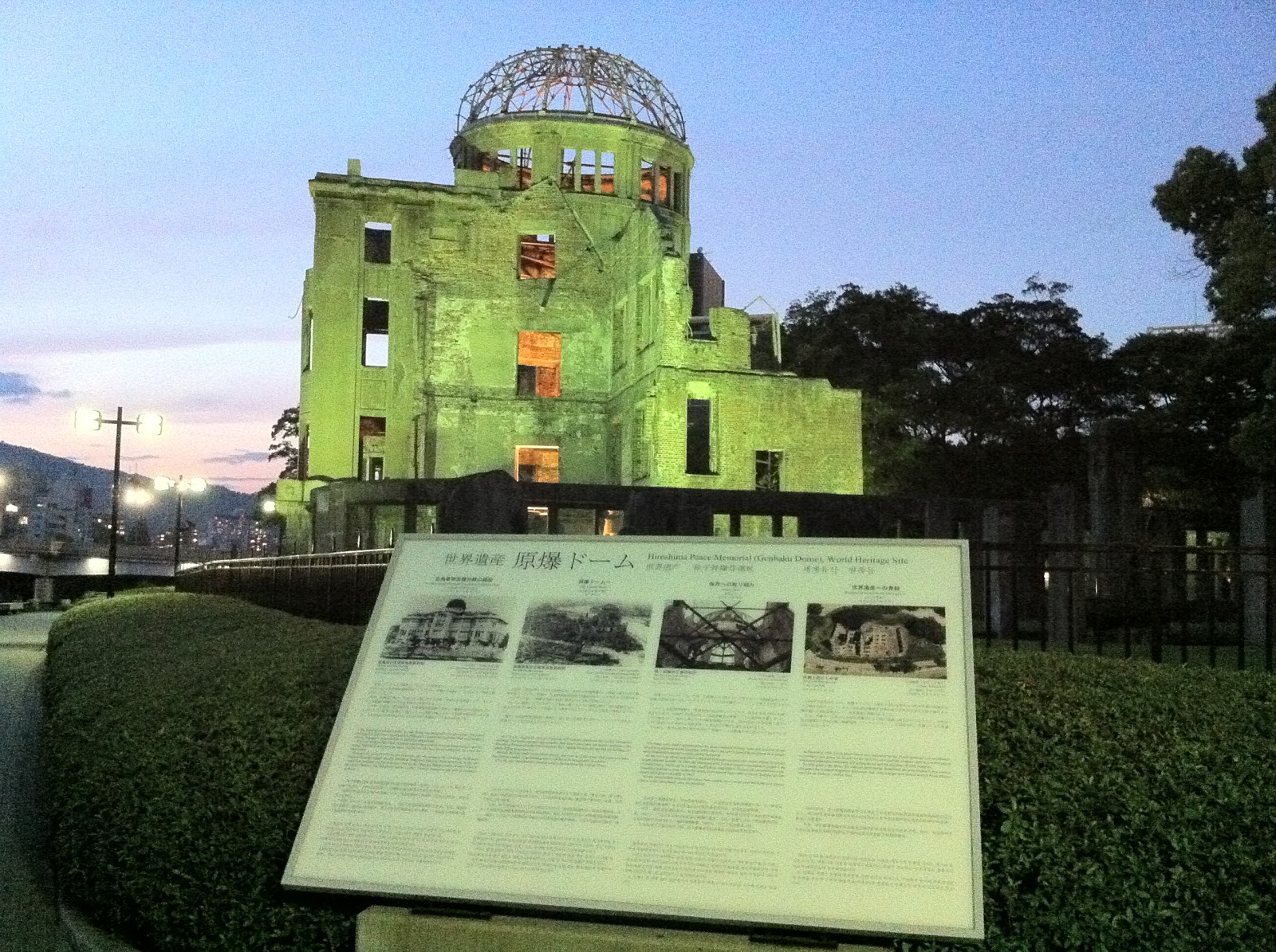
Hiroshima's A-Bomb Dome memorial, taken at dusk when the flood lights came on.  The Peace Memorial Park is small enough to take in in one day, and well constructed to present a powerful message.

Last three shots are of inside the Peace Memorial Museum.  This display asks Why Don't Wars End?  Wow, and that's a very accurate translation of the Japanese.  Naturally, the answer presented is naive and almost completely hollow.

Despite the well-intended but juvenile rhetoric concerning world security affairs, the museum does an excellent job of representing the reality of the bombing.  This display is a sober reminder of what was unleashed on the city.  However, it takes all I can muster to ignore the irony of the large red sphere hanging in the sky, so similar to Japan's national ensign.

Last shot of a display inside another memorial hall in the park.  Once again, only part of Japan's imperial history is presented, focusing on the war with the U.S. but sidestepping the conquest of Asia that preceded our conflict.  I also found it interesting to note the choice of languages this message was chosen to be written in, when there was plenty of room in the exhibit hall to be more international.  


If you would care to read the trip report I will produce concerning this trip, please feel free to contact me.  Until next time...still working on which trip to do in July, will keep posting...


Sunday, May 15, 2011

A day of Sumo

I had the chance to finally see Sumo in person on Sunday May 15. The tournament is kind of different, not being a full grand tournament but a technical examination, so they did not sell normal tickets but gave upper seat tickets away for free. But first come first served, and if you got there later than 0700 you were out of luck for the day! I know because I tried it the day before but came too late. So I planned to gt there on time Sunday morning.

So I got to see a nice sunrise and enjoy uncrowded trains, and then I got to Ryougoku Kokugikan, the Sumo stadium, where I joined a queue of lots of differet people, waited in line for an hour and a half and at 0800 got my ticket!

I then went back to Kokubunji for church, but then returned to Ryougoku at about 1330 to take in as much as I could. The day ends at 1800 with the highest ranking bouts in the last three hours, but all of it was great to experience.

The photos above show how the crowds got bigger as the day progressed, until the house was just about full. I can't wait to take my whole family in September which is when the next tournament occurs in Tokyo.